

GGSA Honored at 2026 KNUST College of Engineering Awards for Advancing Geoscience Education
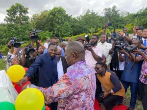
Kumasi, The Ghana Geological Survey Authority (GGSA) has been honored with the Industry Partnership and Excellence in Geoscience Development Award at the 2026 Kwame Nkrumah University of Science and Technology (KNUST) College of Engineering Awards, in recognition of its outstanding contribution to engineering education, geoscientific research, and national resource development.
The award, presented during the College’s annual awards ceremony in Kumasi, celebrated the Authority’s commitment to fostering collaboration between academia and industry while supporting the development of Ghana’s next generation of geological engineers and earth scientists.
Receiving the award on behalf of the Authority, the Deputy Director-General of GGSA, Maria Yusuf (Mrs.), expressed appreciation to the University for the recognition.
Speaking on behalf of Dr. Prosper Akaba, the Director-General of GGSA, Mrs. Maria Yusuf the Deputy Director-General in charge of technical said, “This honor reflects our enduring commitment to advancing geoscience education, promoting responsible mineral resource management, and creating opportunities for students and researchers to apply scientific knowledge to national development”.
The 13th College of Engineering Awards, held on July 23, 2026, which was hinged on the theme, “Inspiring Eminence: Empowering Engineers for a Better Tomorrow.” is a celebration of excellence, achievement, aspiration, and partnership.
The Provost of the KNUST, Professor Kwabena Biritwum Nyarko, commended GGSA for its leadership in bridging the gap between academic research and practical industry application.
“The Ghana Geological Survey Authority has consistently demonstrated its willingness to invest in knowledge sharing, research collaboration, and professional mentorship. Their support continues to enhance the quality of geological engineering education at KNUST,” the Provost noted.
The ceremony brought together government officials, industry leaders, academics, alumni, and students to recognize individuals and institutions whose contributions have significantly strengthened engineering education and innovation in Ghana.
The recognition comes at a time when KNUST and GGSA are strengthening collaboration through initiatives aimed at expanding geological mapping research, improving laboratory and field training, facilitating internships, and promoting joint research projects that address Ghana’s mining, environmental, and infrastructure challenges.
Industry stakeholders attending the event praised the partnership as a model for university-industry collaboration, emphasizing the importance of scientific research in supporting sustainable mining, groundwater exploration, disaster risk reduction, and infrastructure planning.
Students from the Department of Geological Engineering also welcomed the recognition, describing GGSA’s involvement in practical fieldwork and technical training as invaluable to their professional development.
The 2026 KNUST College of Engineering Awards recognized excellence across several categories, including engineering innovation, research, industrial collaboration, academic leadership, and community impact.
Obed Paha, a 4th year student, won the best student award in geological engineering.

GGSA Award for Advancing Geoscience Education
Ceramic and Clay Minerology
Geoscientific Information Management
Marine and Hydrogeology Geology
Engineering and Environmental Geology
Seismology and Geohazard
Geological Mapping
Geochemistry and Laboratory Services
Geophysics
Economic Geology (Mineralogy Exploration and Drill)

Radiometric Ternary Map

Total Magnetic Map
Register with us
Technical Partner in your Geological Works
Conducting research for geological policy and the development of geological strategies and action plans.
Our Latest News
Government Commissions Upgraded National Seismic Monitoring Network to Strengthen Earthquake Preparedness
Lands Minister Armah-Kofi Buah commissioning the upgrade of the national seismic network with GGSA Director-General, Dr. Propsper Akaba Accra, Ghana — The Government of Ghana has officially...
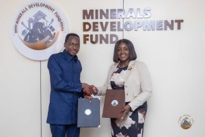
GGSA-MDF PARTNERSHIP, A move to boost responsible corporative Mining
Dr. Akaba in a handshake with Dr. Hanah Bisiw following the signing ceremony The Ghana Geological survey Authority (GGSA) has signed a geological services agreement with the Minerals Development...
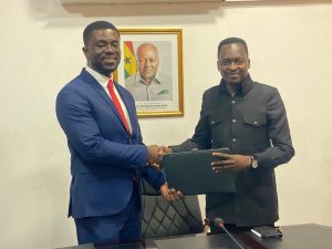
GGSA, Seequent Sign MOU to Advance Geoscience Capacity in Ghana
Dr. Prosper Akaba, GGSA D-G (right) exchanging MoU document with Mr. Seth Miah, the West Africa Regional Manager of Seequent Accra, Ghana — The Ghana Geological Survey Authority (GGSA) has signed a...
Our Official Partners


Company Profile
The Ghana Geological Survey Authority was established as an Authority of the Ministry of Lands and Natural Resources in accordance with Ghana Geological Service Act, 2016 (Act 928)
Useful Links
Contact
No. 6 Mayor Road, Ridge Accra.
Box M80, Ministries Branch. Accra
Tel: +233 050 940 2534
Email: info@ggsa.gov.gh / geosurvey@ggsa.gov.gh